1
/
of
1
Salish Sea Charts
Mappa geographica Provinciæ Nova Eboraci ab Anglis New-York dictæ ex ampliori delineatione ad exactas dimensiones concinnata in arctius spatium redacta cura Claudii Josephi Sauthie by Homann Heirs
Mappa geographica Provinciæ Nova Eboraci ab Anglis New-York dictæ ex ampliori delineatione ad exactas dimensiones concinnata in arctius spatium redacta cura Claudii Josephi Sauthie by Homann Heirs
Regular price
$0.00 USD
Regular price
Sale price
$0.00 USD
Unit price
/
per
Couldn't load pickup availability
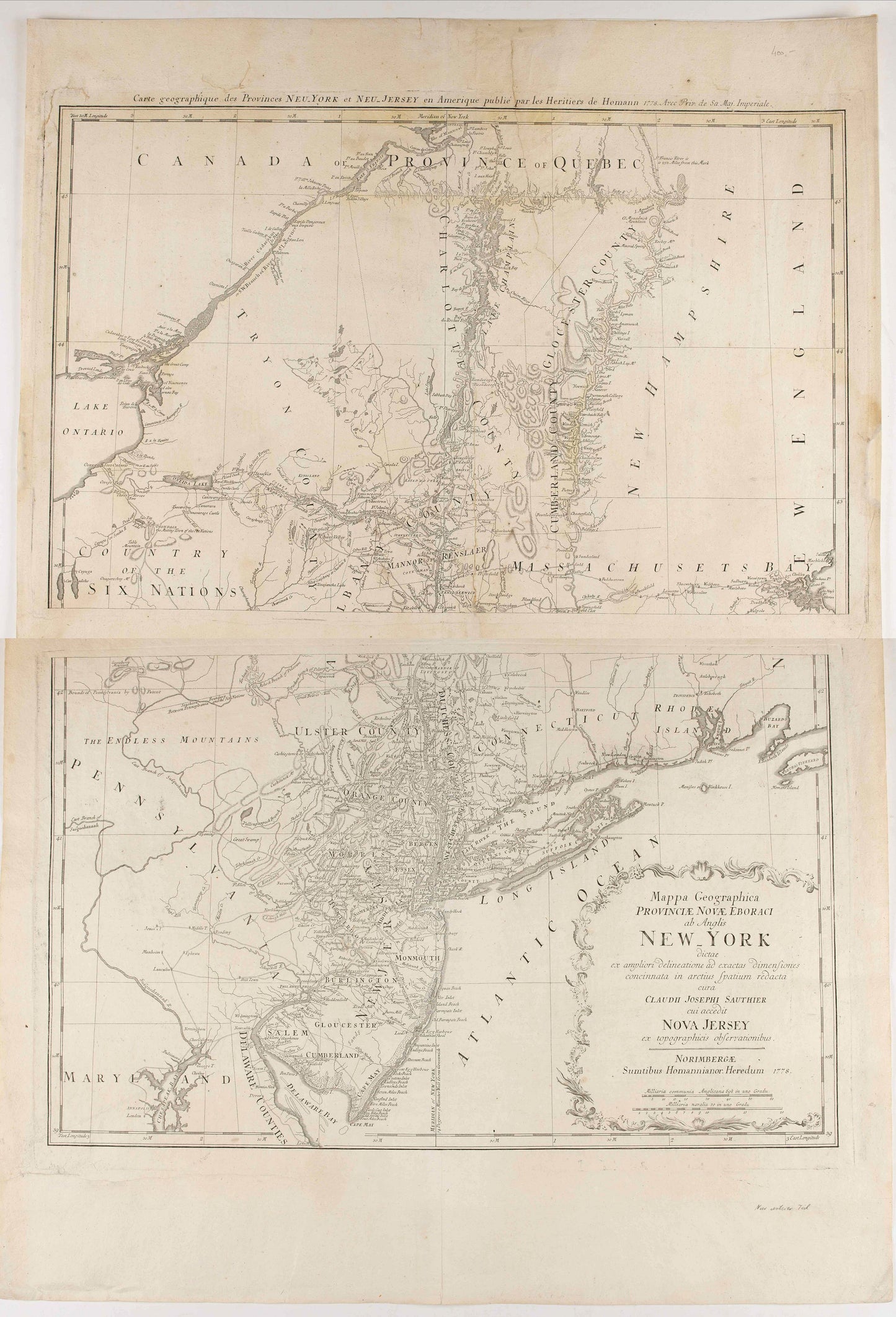
Subject: New York and New Jersey, United States
Creator: Homann Heirs
Date: 1778
Color: Black & White
Size: 28.3 x 22.4 inches
Description:
Mappa geographica Provinciæ Nova Eboraci ab Anglis New-York dictæ ex ampliori delineatione ad exactas dimensiones concinnata in arctius spatium redacta cura Claudii Josephi Sauthier cui accedit Nova Jersey ex topographicis observationibus.
Homann Heirs' edition of Sauthier's celebrated map of New York and New Jersey, made during the Revolutionary War. Also shows portions of Pennsylvania and New England. Relief shown by hachures. Two titles : one in Latin, the other in French. Title in upper margin: Carte geographique des Provinces Neu-York et Neu-Jersey en Amerique publié par les Heritiers de Homann 1778. Avec Prix de sa. Maj. Imperiale.
Appears in Homann's Atlas geographicvs maior. 1759-[1784].
This map afforded British commanders during the Revolution an excellent overview of areas that would be crucial in the early years of the war, in particular the Hudson Valley and Lake Champlain areas. Likewise, New Jersey is well-delineated for the period.
Vermont is still a part of New York State. Many counties named. In the western part of the map, there are a number of marvelous ephemeral names, such as the Endless Mountains. South of Lake Ontario on the Cayuuga River and around Oneida Lake, there are over a dozen Indian Villages shown, along with early forts. The map is a faithful reduction of Faden's 6 sheet map. Despite the Latin Title, the nomenclature is entirely in English.
The dividing line between East and West Jersey is shown, as are boundaries of Pennsylvania, by Patent and other early boundaries.
Many towns and roads are shown. One of the best large format Colonial maps of the region.
Condition: B- due to two sheets, when joined 720x568mm. Paper has been washed, several restorations of splits and paper thinning. In fair condition.
Share