Salish Sea Charts
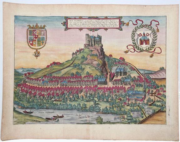
Arx Segeberga, Quondam Aelberga, Wagriam, Nobilem Holsatiae Regionem.. (Castle of Segeberg) by Braun & Hogenberg
Arx Segeberga, Quondam Aelberga, Wagriam, Nobilem Holsatiae Regionem.. (Castle of Segeberg) by Braun & Hogenberg
Couldn't load pickup availability
Subject: Segeberg, Germany
Creator: Braun & Hogenberg
Date: 1588
Color: Colored
Size: 13.2 x 18.3 inch
Description:
This lovely panoramic view depicts the Castle of Segeberg, built in the 12th century upon the Kalkberg, a 91-meter high rock. A small town surrounds the castle. In the foreground flows the Trave River (here called the Stagnum Segebergense) with fishermen casting a net and a number of swans and their goslings. The castle was destroyed in 1644 by Swedish troops. This engraving is based on a drawing by Hans Liefrinck II.
Braun & Hogenberg's Civitates Orbis Terrarum or "Cities of the World" was published between 1572 and 1617. Within the six volumes, 531 towns and cities were depicted on 363 plates, providing the reader with the pleasures of travel without the attendant discomforts. Braun wrote in the preface to the third book, "What could be more pleasant than, in one's own home far from all danger, to gaze in these books at the universal form of the earth . . . adorned with the splendor of cities and fortresses and, by looking at pictures and reading the texts accompanying them, to acquire knowledge which could scarcely be had but by long and difficult journeys?" Braun and Hogenberg incorporated an astonishing wealth of information into each scene beyond the city layout and important buildings. The plates provide an impression of the economy and prominent occupations, and illustrate local costumes, manners and customs.
Condition: A- due to minor aged toned, some foxing, some stains in margin. Text on verso
Share